Conservation Commission
Shelton, Connecticut
 OPEN
SPACE MENU
OPEN
SPACE MENU
Open Space Links
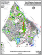
Open Space Map (3mb)
City of Shelton Open Space Marker
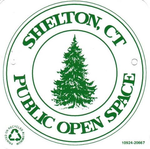
This marker is used to identify Public Open Space owned by the City of Shelton. It does not mark the exact location of the property line and may be as much as 100 feet away from the boundary, depending on site conditions. The Conservation and Pedestrian Easements markers have a similar look but different text.
Land Trust Marker

The Land Trust is a private, non-profit group that owns 364 acres of open space in Shelton, marked with these signs. People frequently confuse the Land Trust with the City of Shelton.
Wetlands Marker
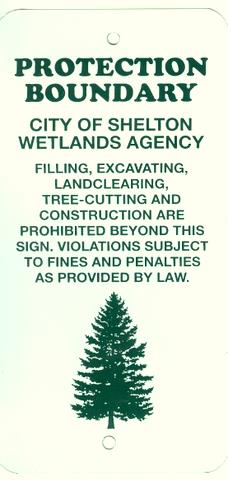
These rectangular wetlands marker may be found in some newer subdivisions, usually on 4x4 posts. They mark the location of areas regulated by the Shelton Inland Wetlands Commission. These are generally on private property and are not related to open space.
Open Space Properties
Municipal open space properties are listed below, sorted by the Open Space number assigned to each property. Brown text indicates a link to more information about that property. To find the Open Space Number, refer to the Open Space Map at the right. Alternatively, use control+F to search this page for a street name or common name people use for the property. Note that Land Trust properties (dark green on the map, with an "LT" prefix) are not owned by the City and are listed on the Land Trust website.
| OS No. | Common Name | Location | Acres | ||
| OS | 1 | Coppel Lane | Coppel Ln Arther Drive |
1.0 | ac. |
| OS | 2.01 | Pine Rock Playground | Long Hill Ave | 0.6 | ac. |
| OS | 2.02 | Pine Rock Playground | Algonkin Rd Mohawk Drive |
1.9 | ac. |
| OS | 3 | Hidden Pond | September Ln | 0.5 | ac. |
| OS | 4 | Honeybee Lane | Honeybee Ln | 1.7 | ac. |
| OS | 5 | Kazo Dr | Kazo Dr | 0.9 | ac. |
| OS | 6 | Mustang Dr | Mustang Dr | 2.1 | ac. |
| OS | 7.01 | Capewell Park | Nichols Ave | 37.2 | ac. |
| OS | 7.02 | Canfield Dr | Canfield Dr | 6.5 | ac. |
| OS | 7.03 | Canfield Dr | Canfield Dr | 2.1 | ac. |
| OS | 7.04 | Meadowlark Dr | Meadowlark Dr | 0.9 | ac. |
| OS | 8 | Brunswick Rd - Louis Dr | Brunswick Rd - Louis Dr | 1.5 | ac. |
| OS | 9 | Hidden Pond | September Ln | 1.2 | ac. |
| OS | 10.01 | Blueberry Ln | Blueberry Ln | 2.9 | ac. |
| OS | 10.02 | Maple Ave | Maple Ave | 0.7 | ac. |
| OS | 11 | South Bank Park | River Rd | 1.7 | ac. |
| OS | 12.01 | Cali Dr | Cali Dr | 2.6 | ac. |
| OS | 12.02 | Autumn Ridge Rd | Autumn Ridge Rd | 4.0 | ac. |
| OS | 13 | River Rd | River Rd | 0.1 | ac. |
| OS | 14.01 | Crossroads | Long Hill Crossroads | 2.5 | ac. |
| OS | 14.02 | Long Hill School | Long Hill Ave | 6.1 | ac. |
| OS | 14.03 | Long Hill School | Long Hill Ave | 5.0 | ac. |
| OS | 15.01 | Stone House Rd | Stone House Rd | 2.1 | ac. |
| OS | 15.02 | Nichols Ave | Nichols Ave | 0.1 | ac. |
| OS | 16 | Ojibwa Rd | Ojibwa Rd | 0.3 | ac. |
| OS | 17 | Waverly Woods | Farmill St | 6.6 | ac. |
| OS | 18 | Nichols Ave | Nichols Ave | 2.5 | ac. |
| OS | 19 | Doe Pl | Doe PL | 1.2 | ac. |
| OS | 20.01 | Ivy Brook | Constitution Blvd S | 3.0 | ac. |
| OS | 20.02 | Ivy Brook | Constitution Blvd S | 6.2 | ac. |
| OS | 20.03 | Ivy Brook | Ivy Brook Rd | 5.8 | ac. |
| OS | 20.04 | Ivy Brook | Ivy Brook Rd | 4.2 | ac. |
| OS | 20.05 | Ivy Brook | Constitution Blvd | 0.6 | ac. |
| OS | 20.06 | Ivy Brook | Constitution Blvd | 0.9 | ac. |
| OS | 21 | River Rd | River Rd | 0.8 | ac. |
| OS | 22 | River Rd | River Rd | 0.6 | ac. |
| OS | 23 | River Rd | River Rd | 14.6 | ac. |
| OS | 24.01 | Farmill St | Farmill St | 31.0 | ac. |
| OS | 24.02 | Winthrop Woods Rd | Winthrop Woods Rd | 2.3 | ac. |
| OS | 25 | Huntington Green | Church St | 1.6 | ac. |
| OS | 26 | Bruce Dr | Bruce Dr | 3.7 | ac. |
| OS | 27.01 | Hope Lake (Res. #3) | Shelton Ave | 79.0 | ac. |
| OS | 27.02 | Shelton Ave | Shelton Ave | 23.6 | ac. |
| OS | 27.03 | Eklund | Oak Valley Rd | 13.6 | ac. |
| OS | 27.04 | Abbey Wright | Nells Rock Rd | 55.6 | ac. |
| OS | 27.04 | Shelton Lakes | Independence Dr | 12.5 | ac. |
| OS | 27.05 | Spooner | Nells Rock Rd | 25.3 | ac. |
| OS | 27.06 | Silent Waters Lake (Res. #1) | Shelton Ave | 84.0 | ac. |
| OS | 27.08 |
Powerlines (Nells Rock) |
Nells Rock/Buddington | 12.6 | ac. |
| OS | 27.09 | Powerlines (Nells Rock) |
Nells Rock/Buddington | 10.9 | ac. |
| OS | 27.10 |
Old Kings Hwy (Nells Rock) |
Nells Rock/Buddington | 11.5 | ac. |
| OS | 27.11 |
Old Kings Hwy (Nells Rock) |
Nells Rock Buddington | 5.0 | ac. |
| OS | 27.12 |
Old Kings Hwy (Nells Rock) |
Nells Rock/Buddington | 6.4 | ac. |
| OS | 27.13 | Hope Lake (Res.#3) | Shelton Ave | 42.0 | ac. |
| OS | 27.14 | Nells Rock Rd | Nells Rock Rd | 1.4 | ac. |
| OS | 27.15 | Pagliaro | Buddington Rd | 7.9 | ac. |
| OS | 27.16 | Huntington Woods (Parcel D) | Wesley Dr | 30.9 | ac. |
| OS | 27.17 | Huntington Woods (Parcel C) | Wesley Dr | 4.5 | ac. |
| OS | 27.18 | Huntington Woods (Parcel E) | Wesley Dr | 15.7 | ac. |
| OS | 27.19 | UI Property | Buddington Rd | 10.9 | ac. |
| OS | 27.2 | Independence Dr | Independence Dr | 0.7 | ac. |
| OS | 28 | Ripton Rd | Ripton Rd | 1.4 | ac. |
| OS | 29 | Wigwam Dr | Wigwam Dr | 0.9 | ac. |
| OS | 30 | Nike Site | Mohegan Rd | 18.2 | ac. |
| OS | 31.01 | Philip Dr | Philip Dr | 9.6 | ac. |
| OS | 31.02 | Philip Dr | Philip Dr | 0.9 | ac. |
| OS | 32 | Mimosa Ln | Mimosa Ln | 1.5 | ac. |
| OS | 33 | Longmeadow Rd | Longmeadow Rd | 2.9 | ac. |
| OS | 34 | Maler Ave | Maler Ave | 5.8 | ac. |
| OS | 35 | Walnut Tree Hill Rd | Walnut Tree Hill Rd | 8.6 | ac. |
| OS | 36.01 | Nells Rock Rd | Nells Rock Rd | 4.6 | ac. |
| OS | 36.02 | Spicebush Ln | Spicebush Ln | 12.1 | ac. |
| OS | 36.03 | Nells Rock Rd | Nells Rock Rd | 5.0 | ac. |
| OS | 37 | Park Ave | Park Ave | 9.9 | ac. |
| OS | 38 | Orchard St | Orchard St | 0.4 | ac. |
| OS | 39 | Sherwood Ln | Sherwood Ln | 6.5 | ac. |
| OS | 40 | Maple Ave | Maple Ave | 4.0 | ac. |
| OS | 41.01 | Brookpine Dr | Brookpine Dr | 1.2 | ac. |
| OS | 41.02 | Brookpine Dr | Brookpine Dr | 1.1 | ac. |
| OS | 42 | Nells Rock Rd | Nells Rock Rd | 3.9 | ac. |
| OS | 43 | Fairlane Dr | Fairlane Dr | 1.9 | ac. |
| OS | 44.01 | Rock Ridge Rd | Rock Ridge Rd | 0.5 | ac. |
| OS | 44.02 | Rock Ridge Rd | Rock Ridge Rd | 3.3 | ac. |
| OS | 45.01 | Meadow St | Meadow St | 1.6 | ac. |
| OS | 45.02 | Ten Coat Ln | Ten Coat Ln | 1.7 | ac. |
| OS | 45.03 | Howe Ave | Howe Ave | 3.9 | ac. |
| OS | 45.04 | Howe Ave | Howe Ave | 2.8 | ac. |
| OS | 45.05 | Howe Ave | Howe Ave | 0.1 | ac. |
| OS | 45.06 | Ten Coat Ln | Ten Coat Ln | 0.4 | ac. |
| OS | 46.01 | Pearmain Rd | Pearmain Rd | 7.8 | ac. |
| OS | 46.02 | Pearmain Rd | Pearmain Rd | 1.3 | ac. |
| OS | 47 | Riverview Park | Howe Ave | 17.7 | ac. |
| OS | 48.01 | From Owl Hill | Leavenworth Rd | 24.6 | ac. |
| OS | 48.02 | The Overlook | Howe Ave | 10.0 | ac. |
| OS | 48.03 | Above the Overlook | Leavenworth Rd | 9.8 | ac. |
| OS | 48.04 | Aside the Overlook | Leavenworth Rd | 6.0 | ac. |
| OS | 48.05 | Leavenworth Rd | Leavenworth Rd | 8.4 | ac. |
| OS | 48.06 | Housatonic Rise | Leavenworth Rd | 2.7 | ac. |
| OS | 48.07 | Howe Ave | Howe Ave | 7.6 | ac. |
| OS | 48.08 | Meadow St (rear) | Meadow St | 23.8 | ac. |
| OS | 48.09 | Howe Ave | Howe Ave | 1.3 | ac. |
| OS | 49 | Four Winds | Mountain View Dr | 17.6 | ac. |
| OS | 50 | Barn Hill Rd | Barn Hill Rd | 32.1 | ac. |
| OS | 51 | E. Village Rec. Park | E. Village Rd | 29.8 | ac. |
| OS | 52.01 | Thoreau Dr | Thoreau Dr | 12.4 | ac. |
| OS | 52.02 | Vista Dr | Vista Dr | 3.7 | ac. |
| OS | 52.03 | E. Village Rd | E. Village Rd | 1.1 | ac. |
| OS | 52.04 | Vista Dr | Vista Dr | 8.1 | ac. |
| OS | 52.05 | E. Village Rd | E. Village Rd | 0.7 | ac. |
| OS | 52.06 | Meghan Ct (rear) | Meghan Ct (rear) | 0.2 | ac. |
| OS | 53.01 | Dickinson Dr | Dickinson Dr | 5.9 | ac. |
| OS | 53.02 | Shelter Rock -x | Vista Dr | 2.4 | ac. |
| OS | 53.03 | Thoreau Dr | Thoreau Dr | 1.9 | ac. |
| OS | 53.04 | Thoreau Dr | Thoreau Dr | 0.3 | ac. |
| OS | 53.05 | Vista Dr | Vista Dr | 1.9 | ac. |
| OS | 54 | E. Village Rd | E. Village Rd | 2.4 | ac. |
| OS | 55.01 | Golden Hill Ln | Golden Hill Ln | 2.7 | ac. |
| OS | 55.02 | Golden Hill Ln | Golden Hill Ln | 2.1 | ac. |
| OS | 55.03 | Golden Hill Ln | Golden Hill Ln | 1.7 | ac. |
| OS | 55.04 | Golden Hill Ln | Golden Hill Ln | 8.7 | ac. |
| OS | 56 | Old Farm Rd | Old Farm Rd | 7.9 | ac. |
| OS | 57.01 | Ridge Ln | Ridge Ln | 1.5 | ac. |
| OS | 57.02 | Laurel Ledge | Constitution Blvd | 2.5 | ac. |
| OS | 57.03 | Ridge Ln | Ridge Ln | 0.6 | ac. |
| OS | 57.04 | Ridge Ln | Ridge Ln | 0.5 | ac. |
| OS | 57.05 | Constitution Blvd | Constitution Blvd | 0.1 | ac. |
| OS | 57.06 | Constitution Blvd S | Constitution Blvd S | 0.1 | ac. |
| OS | 57.07 | Constitution Blvd | Constitution Blvd | 0.1 | ac. |
| OS | 57.08 | Steep Brook Ln | Steep Brook Ln | 0.6 | ac. |
| OS | 57.09 | Constitution Blvd | Constitution Blvd | 0.1 | ac. |
| OS | 57.10 | East Ave | East Ave | 0.2 | ac. |
| OS | 57.11 | East Ave | East Ave | 0.2 | ac. |
| OS | 58.01 | Hiawatha Trl | Hiawatha Trl | 2.2 | ac. |
| OS | 58.02 | Hiawatha Trl | Hiawatha Trl | 0.2 | ac. |
| OS | 59 | Thoreau Dr | Thoreau Dr | 10.6 | ac. |
| OS | 60.01 | Warwick Ln | Warwick Ln | 1.0 | ac. |
| OS | 60.02 | Warwick Ln | Warwick Ln | 1.0 | ac. |
| OS | 61.01 | Constitution Blvd | Constitution Blvd | 0.6 | ac. |
| OS | 61.02 | Meadow St | Meadow St | 4.5 | ac. |
| OS | 62 | Buddington Rd | Buddington Rd | 15.6 | ac. |
| OS | 62.02 | Turkey Hill/ Old Kings Hwy |
Maggie Lane | 4.2 | ac. |
| OS | 63.01 | Fawn Meadow Ln | Fawn Meadow Ln | 5.9 | ac. |
| OS | 63.02 | Fawn Meadow Ln | Fawn Meadow Ln | 0.2 | ac. |
| OS | 64.01 | Beech Tree Hill Rd | Beech Tree Hill Rd | 4.3 | ac. |
| OS | 64.02 x | Big Horn Rd | Big Horn Rd | 34.1 | ac. |
| OS | 64.03 | Pine Tree Hill Rd | Pine Tree Hill Rd | 2.0 | ac. |
| OS | 64.04 | Beech Tree Hill Rd | Beech Tree Hill Rd | 4.6 | ac. |
| OS | 64.05 | White Birch Ct | White Birch Ct | 0.5 | ac. |
| OS | 64.06 | Pine Tree Hill Rd | Pine Tree Hill Rd | 3.2 | ac. |
| OS | 65 | Perch Rd | Perch Rd | 0.3 | ac. |
| OS | 66 | Columbia Dr | Columbia Dr | 2.6 | ac. |
| OS | 67.01 | Little Fox Run | Little Fox Run | 1.4 | ac. |
| OS | 67.02 | Little Fox Run | Little Fox Run | 0.2 | ac. |
| OS | 67.03 | Little Fox Run | Little Fox Run | 0.4 | ac. |
| OS | 67.04 | Little Fox Run | Little Fox Run | 9.3 | ac. |
| OS | 68.01 | Ivy Brook | Plaskon Dr Extension | 0.4 | ac. |
| OS | 68.02 | Ivy Brook | Plaskon Dr Extension | 0.2 | ac. |
| OS | 68.03 |
Ivy Brook |
Plaskon Dr Extension | 0.5 | ac. |
| OS | 68.04 | Sanford Dr | Sanford Dr | 5.3 | ac. |
| OS | 69 | Soundview Ave | Soundview Ave | 6.2 | ac. |
| OS | 70.01 | Rugby Rd | Rugby Rd | 4.8 | ac. |
| OS | 70.02 | Rugby Rd | Rugby Rd | 0.1 | ac. |
| OS | 71 | Nichols Ave | Nichols Ave | 5.0 | ac. |
| OS | 72.01 | Wellington Ct | Wellington Ct | 0.8 | ac. |
| OS | 72.02 | Independence Dr | Independence Dr | 16.0 | ac. |
| OS | 73 | Sims Way | Sims Way | 0.9 | ac. |
| OS | 74.01 | Hidden Pond | Hidden Pond Ln | 1.0 | ac. |
| OS | 74.02 | Hidden Pond | Hidden Pond Ln | 6.8 | ac. |
| OS | 75 | Beardsley Rd | Beardsley Rd | 10.9 | ac. |
| OS | 76 | Sterling Ridge | Sterling Ridge | 1.7 | ac. |
| OS | 77 | Longmeadow Rd | Longmeadow Rd | 0.8 | ac. |
| OS | 78 | Isinglass Rd | Isinglass Rd | 2.7 | ac. |
| OS | 79 | Isinglass Rd | Isinglass Rd | 3.5 | ac. |
| OS | 80.01 | Constitution Blvd N | Constitution Blvd N | 12.3 | ac. |
| OS | 80.02 | Wiacek Farm | Meadow St | 40.3 | ac. |
| OS | 80.03 | Soundview Ave | #279 Soundview | ||
| OS | 81 | Hubbell Ln | Hubbell Ln | 1.7 | ac. |
| OS | 82.01 |
Pine Lake |
Shelton Ave | 27.3 | ac. |
| OS | 82.02 | Shelton Ave | Shelton Ave | 9.2 | ac. |
| OS | 83.01 | Leavenworth Rd | Leavenworth Rd | 2.8 | ac. |
| OS | 83.02 | Vistas of White Hills - Parcel B | Wabuda Pl | 6.0 | ac. |
| OS | 84 | Mustang Dr | Mustang Dr | 6.0 | ac. |
| OS | 85.01 | Beard Sawmill Rd | Beard Sawmill Rd | 0.9 | ac. |
| OS | 85.02 | Well Spring Estates | Old Stratford Rd | 6.3 | ac. |
| OS | 86 | River Rd | River Rd | 1.6 | ac. |
| OS | 87 | Mohegan Rd | Mohegan Rd | 2.0 | ac. |
| OS | 88 | Housatonic Heights | Old Coram Rd | 2.4 | ac. |
| OS | 89 | Pearl Bach | Manhassett Trail | 0.3 | ac. |
| OS | 90.01 | Huntington Well Field | Huntington St | 37.7 | ac. |
| OS | 90.02 | Serene Dr | Serene Dr | 1.1 | ac. |
| OS | 90.03 | Lane St | Lane St | 0.9 | ac. |
| OS | 91 | Huntington St | Huntington St | 25.5 | ac. |
| OS | 92.01 | Gristmill Trail | Mill St | 1.1 | ac. |
| OS | 92.02 | Gristmill Trail | Commerce Dr | 1.8 | ac. |
| OS | 93 | Sawmill City Rd | Sawmill City Rd | 29.1 | ac. |
| OS |
94.01
| Birchbank |
Birchbank |
91.5 |
ac. | |
| OS | 94.02 | Old Farm Rd | Old Farm Rd | 26.1 | ac. |
| OS | 95.01 | Hayfield Dr | Hayfield DR | 1.6 | ac. |
| OS | 95.02 | Hayfield Dr | Hayfield Dr | 2.9 | ac. |
| OS | 96.01 | Pasture Ln | Pasture Ln | 21.8 | ac. |
| OS | 96.02 | Soundview Ave | Soundview Ave | 1.0 | ac. |
| OS | 96.03 | Emerald Ridge Ct | Emeral Ridge Ct | 1.4 | ac. |
| OS | 96.04 | Constitution Blvd N ROW | Constitution Blvd N | 2.5 | ac. |
| OS | 96.05 | Plum Tree Ln | Plum Tree Ln | 0.4 | ac. |
| OS | 96.06 | Plum Tree Ln | Plum Tree Lane | 3.6 | ac. |
| OS | 97 | Constitution Park | Constitution Blvd S | 1.8 | ac. |
| OS | 98 | Beech Tree Hill Rd | Beech Tree Hill Rd | 1.6 | ac. |
| OS | 99 | Waverly Rd | Waverly Rd | 2.5 | ac. |
| OS | 100 | Lane St | Lane St | 5.6 | ac. |
| OS | 101 | Maple Ave | Maple Ave | 5.6 | ac. |
| OS | 102.01 | Beardsley Rd | Beardsley Rd | 5.4 | ac. |
| OS | 102.02 | Beardsley Rd | Beardsley Rd | 1.1 | ac. |
| OS | 103 | Beardsley Rd | Beardsley Rd | 1.0 | ac. |
| OS | 104 | Buddington Rd | Buddington Rd | 4.5 | ac. |
| OS | 105.01 | Long Hill School-Klapik | Long Hill Ave | 16.4 | ac. |
| OS | 105.02 | Klapik Farm | Long Hill Ave | 19.2 | ac. |
| OS | 105.03 | Klapik Farm | Long Hill Ave | 22.8 | ac. |
| OS | 106 | Birdseye Rd | Birdseye Rd | 1.9 | ac. |
| OS | 107 | Mount Pleasant St | Mount Pleasant St | 1.8 | ac. |
| OS | 108 | River Rd | River Rd | 3.7 | ac. |
| OS | 109.01 | Winthrop Woods Rd | Winthrop Woods Rd | 17.3 | ac. |
| OS | 110.01 | Clinton Dr | Clinton Dr | 1.9 | ac. |
| OS | 110.02 | Clinton Dr | Clinton Dr | 1.1 | ac. |
| OS | 111 | Wopowog Tr | Wopowog Tr | 0.3 | ac. |
| OS | 112.01 | Oak Valley Rd | Oak Valley Rd | 1.2 | ac. |
| OS | 112.02 | Oak Valley Rd | Oak Valley Rd | 3.4 | ac. |
| OS | 113 | Clinton Dr | Clinton Dr | 1.1 | ac. |
| OS | 114 | Lane St | Lane St | 0.9 | ac. |
| OS | 115 | Huntington Woods (Parcel B) | Lane St | 3.3 | ac. |
| OS | 116 | Soundview Ave | Soundview Ave | 2.2 | ac. |
| OS | 117 | Plum Tree Ln | Plum Tree Ln | 1.3 | ac. |
| OS | 118 | Meadow St | Meadow St | 4.5 | ac. |
| OS | 119.01 | Old Coram Rd | Old Coram Rd | 6.8 | ac. |
| OS | 119.02 | Tall Farm | Long Hill Ave | 33.9 | ac. |
| OS | 120.01 | Shelton Ave | Shelton Ave | 2.9 | ac. |
| OS | 120.02 | Maler Ave - Parcel "B" | Maler Ave | 3.8 | ac. |
| OS | 121.01 | Parcel "B" | Long Hill Ave | 3.2 | ac. |
| OS | 121.02 | Wintergreen Ln | Wintergreen Ln | 1.1 | ac. |
| OS | 121.03 | Parcel "A" | Wintergreen Ln | 0.9 | ac. |
| OS | 122.01 | French's Hill | East Village Rd | 105.1 | ac. |
| OS | 122.02 | Vistas of White Hills - Parcel A | E. Village Rd | 6.5 | ac. |
| OS | 123 | Yutaka Tr | Yutaka Tr | 0.1 | ac. |
| OS | 124 | Yutaka Tr | Yutaka Tr | 0.1 | ac. |
| OS | 125 | Wigwam Tr | Wigwam Tr | 0.2 | ac. |
| OS | 126 | Wenonah Trl | Wenonah Trl | 0.3 | ac. |
| OS | 127 | Long Hill Ave | Long Hill Ave | 0.3 | ac. |
| OS | 128 | Orowac Trail | Orowoc Trail | 0.1 | ac. |
| OS | 129 | Rolling Brook Ln | Rolling Brook Ln | 0.1 | ac. |
| OS | 130 | Waverly Rd | Waverly Rd | 0.2 | ac. |
| OS | 131 | Old coram Rd | Old Coram Rd | 0.4 | ac. |
| OS | 132 | Autumn Ridge Rd | Autumn Ridge Rd | 0.3 | ac. |
| OS | 133 | Copper Penny Ln | Copper Penny Ln | 0.1 | ac. |
| OS | 134 | Partridge Ln | Partridge Ln | 0.0 | ac. |
| OS | 135 | Old Mill Rd | Old Mill Rd | 0.0 | ac. |
| OS | 136 | Shinnacock Trl | Shinnacock Trl | 0.2 | ac. |
| OS | 137 | Hillside Ave | Hillside Ave | 0.1 | ac. |
| OS | 138 | Sunnyside Dr | Sunnyside Dr | 0.0 | ac. |
| OS | 139.01 | Tuxedo Ave | Tuxedo Ave | 0.1 | ac. |
| OS | 139.02 | Tuxedo Ave | Tuxedo Ave | 0.1 | ac. |
| OS | 139.03 | Tuxedo Ave | Tuxedo Ave | 0.1 | ac. |
| OS | 139.04 | Tuxedo Ave | Tuxedo Ave | 0.1 | ac. |
| OS | 139.05 | Tuxedo Ave | Tuxedo Ave | 0.4 | ac. |
| OS | 139.06 | Tuxedo Ave | Tuxedo Ave | 0.1 | ac. |
| OS | 140 | Hazel St | Hazel St | 0.3 | ac. |
| OS | 141.01 | Tuxedo Ave | Tuxedo Ave | 0.1 | ac. |
| OS | 141.02 | Coram Rd | Coram Cr | 0.1 | ac. |
| OS | 141.03 | Coram Ave | Coram Ave | 0.1 | ac. |
| OS | 141.04 | Tuxedo Ave | Tuxedo Ave | 0.1 | ac. |
| OS | 141.05 | Tuxedo Ave | Tuxedo Ave | 0.1 | ac. |
| OS | 142 | Frank Dr | Frank Dr | 0.4 | ac. |
| OS | 143.01 | Mas Property - Heritage Dr | Heritage Dr | 27.5 | ac. |
| OS | 143.02 | Mas Property - Heritage Dr | Heritage Dr | 6.5 | ac. |
| OS | 143.03 | Mas Property - Heritage Dr | Heritage Dr | 7.6 | ac. |
| OS | 143.04 | Mas Property - Heritage Dr | Heritage Dr | 6.2 | ac. |
| OS | 143.05 | Mas Property - Constitution Blvd | Constitution Blvd | 9.0 | ac. |
| OS | 143.06 | Blacks Hill Rd | Blacks Hill Rd | 2.6 | ac. |
| OS | 143.07 | Blacks Hill Rd | Blacks Hill Rd | 0.5 | ac. |
| OS | 143.08 | Constitution Blvd | Constitution Blvd | 1.3 | ac. |
| OS | 143.09 | Constitution Blvd | Constitution Blvd | 1.0 | ac. |
| OS | 144 | Lane St | Lane St | 0.1 | ac. |
| OS | 145 | Roberts St | Roberts St | 0.1 | ac. |
| OS | 146 | Birchbank | Birchbank | 0.2 | ac. |
| OS | 147 | Yutaka Tr | Yutaka Tr | 0.3 | ac. |
| OS | 149.01 | Veterans Memorial Park | Canal St | 1.1 | ac. |
| OS | 149.02 | Veterans Riverwalk Park | Canal St | 1.3 | ac. |
| OS | 149.03 | Riverwalk Park | Canal St | 1.6 | ac. |