Conservation Commission
Shelton, Connecticut
 OPEN
SPACE MENU
OPEN
SPACE MENU
Open Space Links
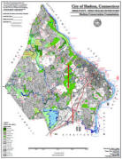
Open Space Map (3mb)
City of Shelton Open Space Marker
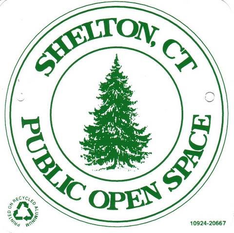
This marker is used to identify Public Open Space owned by the City of Shelton. It does not mark the exact location of the property line and may be as much as 100 feet away from the boundary, depending on site conditions. The Conservation and Pedestrian Easements markers have a similar look but different text.
Land Trust Marker

The Land Trust is a private, non-profit group that owns 364 acres of open space in Shelton, marked with these signs. People frequently confuse the Land Trust with the City of Shelton.
Wetlands Marker
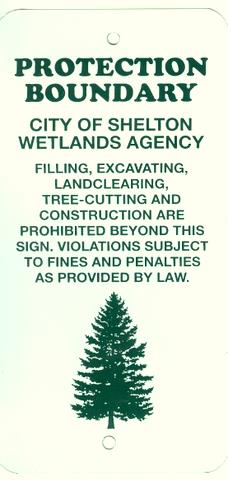
These rectangular wetlands marker may be found in some newer subdivisions, usually on 4x4 posts. They mark the location of areas regulated by the Shelton Inland Wetlands Commission. These are generally on private property and are not related to open space.
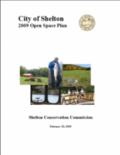
Open Space Plan 0f 2009
 Conservation's
Open Space Plan is a supplement to the Planning and Zoning Commission's
Plan of Conservation and Development.
Conservation's
Open Space Plan is a supplement to the Planning and Zoning Commission's
Plan of Conservation and Development.
View the plan online (hard copies may be purchased from the Planning and Zoning office, City Hall Room 303):
- Plan body (11 mb, MSWord)
- Action Plan (MS Word)
- Appendices:
- A-F. Inventories (Excel; Each appendix is a separate worksheet within the document)
- G. Greenway Map (pdf - 6 mb)
- G. Existing Open Space Map (pdf - 6 mb) (now obsolete - see updated 2014 Open Space Map)
- H. Definitions (MSWord)
Executive Summary
This Open Space Plan was prepared by the Conservation Commission and
adopted by the Planning and Zoning Commission on February 10, 2009 as a
supplement the 2006 Plan of Conservation and Development. It replaced
the Open Space Plan of 1993 upon its effective date of February 20,
2009.
Open space lands are a critical component of a balance community.
Conservation areas provide recreational opportunities to residents,
enhance the esthetics of the community, and improve water quality and
provide wildlife habitat. Compared to residential development, these
areas reduce the tax burden by reducing traffic, school enrollment, and
other infrastructure demands.
The City of Shelton’s goal is to preserve at least 3,060 acres, or
fifteen percent of the land area, in the form of locally controlled
“community” open space, including City of Shelton Public Open Space,
privately held farmland preserved through the purchase of development
rights, and lands owned by the Shelton Land Conservation Trust.
Properties managed by the state have historically been excluded from the
community open space goal. A total of 2,700 acres (13.2%) have now been
acquired for open space, although not all parcels are permanently
protected open space as some these of these lands were purchased for
potential provision of future roads or other facilities and may be
removed from later inventories. To meet this goal, the City needs to
acquire roughly 450 acres of additional open space through a combination
of subdivision set-asides and the purchase of land and development
rights. There are about 3000 acres of vacant or underdeveloped land
remaining in Shelton.
The quality of the open space inventory should be enhanced, whenever
possible, so that it does not exist solely of wetlands or steep slopes,
is accessible to the general public, and is contiguous with existing
open space. Continuous, interconnected open space properties provide
more ecological and recreational benefits as compared to scattered
fragments of land, and for this reason the greenway program has been
expanded.
Four conceptual greenways were established in 1993: The Housatonic
River, Far Mill River, Means Brook, and Shelton Lakes Greenways.
Conceptual greenways constitute areas of special interest, within which
the City may prioritize open space purchases and review proposed
developments for impacts to the greenway. Substantial progress has been
achieved in acquiring properties within these greenways, particularly
within the Shelton Lakes Greenway, which now contains over 450 acres of
contiguous open space and ten miles of hiking trails. This Plan
recognizes three new greenways: Long Hill, Trap Falls and Ivy Brook
Greenways.
The Open Space Plan of 1993 focused primarily on open space acquisition.
During the intervening years, our open space inventory has more that
doubled as the City acquired open space at an average rate of over 125
acres per year to keep pace with rapid development. This Plan addresses
increasingly important management issues, including the rising demand
for facilities such as community gardens and ballfields.
Farmland preservation is a key component of this plan, particularly
within the White Hills, where Shelton is ideally suited for agritourism.
The formation of a White Hills Agricultural district is encouraged. An
agricultural district would be an overlay area of special interest,
similar to our greenways concept, designed to focus attention on
Shelton’s remaining farmland. The district could be used for marketing
purposes, to promote agritourism, and to obtain agricultural grants.
The purchase of development rights allows landowners to continue farming
their land, while preserving it from housing developments. However,
successful farmland preservation efforts utilize more than land
preservation, since farming must be made economically viable for it to
continue. Farmer’s Markets, community marketing, flexible zoning, “right
to farm” ordinances, compatible attractions, and preservation of the
rural and scenic atmosphere help to keep farmers in business.
Resources valued by the community such as historic sites, scenic
features, sensitive or unique ecosystems, trails, or waterways should be
preserved whenever possible. A Community Resources Inventory Committee
should be established to identify and prioritize such features in the
City so they may be incorporated into the GIS system and used for
planning purposes.