Conservation Commission
Shelton, Connecticut
 OPEN
SPACE MENU
OPEN
SPACE MENU
Open Space Links
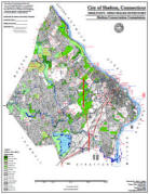
Open Space Map (3mb)
City of Shelton Open Space Marker
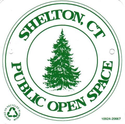
This marker is used to identify Public Open Space owned by the City of Shelton. It does not mark the exact location of the property line and may be as much as 100 feet away from the boundary, depending on site conditions. The Conservation and Pedestrian Easements markers have a similar look but different text.
Land Trust Marker

The Land Trust is a private, non-profit group that owns 364 acres of open space in Shelton, marked with these signs. People frequently confuse the Land Trust with the City of Shelton.
Wetlands Marker
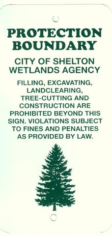
These rectangular wetlands marker may be found in some newer subdivisions, usually on 4x4 posts. They mark the location of areas regulated by the Shelton Inland Wetlands Commission. These are generally on private property and are not related to open space.
Open Space Acquisitions
The City of Shelton preserves conservation lands using several different methods:
Subdivision Regulations
Developers are required to donate a minimum of 10% of their land to the City for public open space. Alternatively, they may donate a fee in lieu of open space, which is deposited in the Open Space Trust Account to be used to purchase open space. The 2006 Plan of Conservation and Development and the Open Space of 2009 recommend an increase in the open space requirement to 15%.
Alternative PRD and CRD developments may be used to increase the percentage of open space preserved. The PRD (Planned Residential District) allows for a density bonus, while the CRD (Conservation Residential District) does not. Both alternatives allow for reduced set-backs, reduced lot sizes, and other variances from standard subdivision regulations, which may reduce the costs of developing a site.
Conservation easements are often required as conditions of approval to buffer existing homes from new development, to protect natural resources, or to buffer City open space properties. In such cases the City does not own the land, but does own an easement over that land that precludes building, cutting or filling.
Purchase "In Fee"
The City maintains an Open Space Trust Account that is used for the purchase of open space, and which is funded by the City at a rate of $250,000 per year.
Larger open space purchases are funded directly by the Board of Aldermen via the bond process. These purchases may require a referendum, which have always passed by a wide margin as shown in the table below.
|
Open Space Referendums |
||
|
Year |
Amount |
Approval |
|
1997
|
$7 million |
89% |
|
2003 |
$2 million |
72% |
|
2004 |
$3 million |
78% |
|
2006 |
$4.3 million |
75% |
Purchase of Development Rights
Often used for farmland preservation, this preservation technique allows the landowner to continue to own and farm the property, while ensuring that it is not subdivided into housing tracts. This strategy provides the maximum economic benefit for taxpayers because there are no City maintenance costs associated with the property, the landowner continues to pay taxes on the farm business, and City expenses for schools, sewers and road that would have been required by a new development are prevented. There are currently eight properties in Shelton that have been preserved using this technique, all located in the White Hills. These include Jones Family Farm, Shelton Family Farm, Beardsley Organic Farm, and Stockmal Woods.
Donation
Property owners may donate land or conservation easements to the City or to the Shelton Land Conservation Trust (a private organization). In some cases, landowners effectively donate a portion of the value of the land they are selling by reducing the sale price. Jones Family Farm, for example, reduced their purchase price by 25%. Donations may be tax deductible. Properties may be deed restricted to ensure they are preserved as conservation lands.
Prioritizing Land Purchases
The Board of Aldermen determine all open space purchases, with input provided by the Conservation Commission. The Commission ranks all potential purchases based on factors such as whether the land is:
- located within one of the City's conceptual greenways, as defined in the Open Space Plan
- adjacent to existing open space
-
allows for trail linkage
-
contains unusual natural resources or ecosystems (rock formations, tidal wetlands, cranberry bog)
-
is scenic (waterfalls, ponds, view points)
-
has historic value (Indian artifacts, colonial roads, old mill ruins)
-
provides public access to attractions such as the Housatonic or Far Mill Rivers
-
Protects vulnerable lands or water quality, such as the shoreline of the Far Mill River
-
May provide for future recreational opportunities (such as ballfields or community gardens).
-
Is located in a residential zone (provides greater economic benefit to taxpayers).
-
Is available for a reasonable price